

Bundle
90
Fishlake National Forest Atlas
- Hiking
- Hunting
$19.99 USD
Fishlake National Forest Atlas
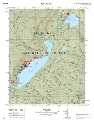
National Forest Atlases are full color atlases, containing 8.5-inch by 11-inch topographic quadrangle maps at 1 inch to the mile scale.
National Forest Atlases are full color atlases, containing 8.5-inch by 11-inch topographic quadrangle maps at 1 inch to the mile scale.
Geographic area:
Category:
Parks & Forests
Size:
252.26MB
Publication:
June 2018
Language:
English
Map bounds
Maps included in this bundle
This bundle contains 90 maps
Parks & Forests
Fishlake National Forest, Water Creek Canyon, UT 39
US Forest Service R4
- Backroading
- Hiking


Parks & Forests
Fishlake National Forest, Dog Valley Peak, UT 34
US Forest Service R4
- Backroading
- Hiking

Parks & Forests
Fishlake National Forest, Old Woman Plateau, UT 32
US Forest Service R4
- Backroading
- Hiking

What you get with Avenza Maps

Reliable mapping tools
Record GPS tracks, add placemarks, add photos, measure distances, and much more.

Locate yourself with GPS
Avenza Maps offline GPS app on your mobile device can locate you on any map, without WiFi or network connectivity.

The best maps by the best publishers
Download professionally curated digital maps on the Avenza Map Store from the best-renowned publishers.