

1
BLM - Cache Creek Wilderness
- Cycling
- Fishing
- Hiking
- Horseback Riding
- Hunting
Free
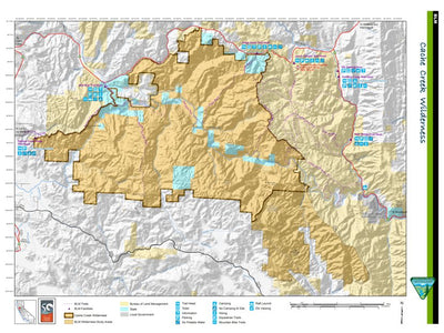
The prominent feature within the Cache Creek Wilderness is Cache Creek, which bisects the new wilderness area and forms a rugged steep-sided canyon. Steep canyon walls occasionally open to broad grassy meadows with scattered valley oaks, such as Baton Flat, Wilson Valley, and Kennedy Flats. Num...
Geographic area:
Category:
Parks & Forests
Size:
11.08MB
Publication:
2014
Language:
English
Map bounds
Check nearby maps Customer Reviews
4.0 Based on 1 Reviews
Write a Review Ask a Question - Reviews
- Questions
Filter Reviews:
- valleys
- hill
- Baton Flat
- firepit
- Creek
- Redbud Trail
- Wilson Valley
- someone
- contour lines
- Trail routes
A
11/01/2023
Anonymous
I recommend this product
good map with precision trail
We hiked Redbud Trail following the map to Baton Flat, then up hill and down hill again till the north edge of Wilson Valley where there is firepit by a dry creek. The only improvement I wish is that the scale can be finer than 200 ft contour lines. Then some smaller hills and valleys will be shown in case someone needs to explore off trail routes like us.
What you get with Avenza Maps

Reliable mapping tools
Record GPS tracks, add placemarks, add photos, measure distances, and much more.

Locate yourself with GPS
Avenza Maps offline GPS app on your mobile device can locate you on any map, without WiFi or network connectivity.

The best maps by the best publishers
Download professionally curated digital maps on the Avenza Map Store from the best-renowned publishers.