

4
Motor Vehicle Use Map, MVUM, Osceola National Forest
- Backroading
- Off-roading
Free
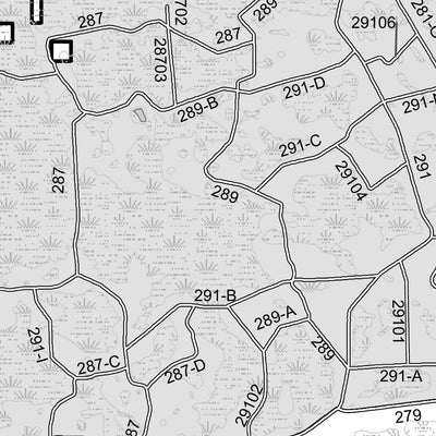
The printed USDA Forest Service Motor Vehicle Use Map (MVUM) from which this map was derived, is a free, single-purpose, black-and-white map that displays those roads, trails, and areas designated for motor vehicle use on a particular national forest or grassland. Routes not designated for motor ...
Geographic area:
Category:
Trails
Size:
20.28MB
Publication:
January 2018
Language:
English
Map bounds
Check nearby maps Customer Reviews
5.0 Based on 4 Reviews
Write a Review Ask a Question - Reviews
- Questions
Filter Reviews:
- Osceola Forest
- road
- area
- five
A
03/18/2024
Anonymous
United States
I recommend this product
Easy to use
The maps were easy to use and provided the detail I needed to easily navigate the trails.
03/31/2023
Anonymous
I recommend this product
Avenza Osceola MVUM
Downloaded the free app and the free Osceola MVUM map five minutes before entering the Osceola Forest. The app was very easy to use and worked perfect. All the roads are on the map, do not use any road not on the map. Will try a different area next time...
C
11/02/2021
Customer
Middleburg, Florida, United States
Motor Vehicle Use Map, MVUM, Osceola National Forest
What you get with Avenza Maps

Reliable mapping tools
Record GPS tracks, add placemarks, add photos, measure distances, and much more.

Locate yourself with GPS
Avenza Maps offline GPS app on your mobile device can locate you on any map, without WiFi or network connectivity.

The best maps by the best publishers
Download professionally curated digital maps on the Avenza Map Store from the best-renowned publishers.