6
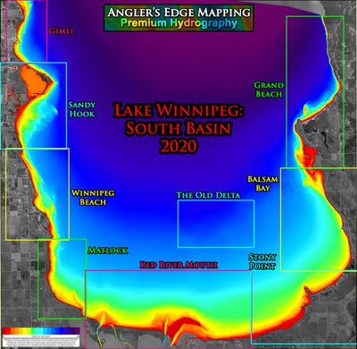
AEM Lake Winnipeg: south basin 2020 overview (FREE)
- Fishing
- Hunting
This product can also be purchased as part of the following bundle(s).
Free
Free low-resolution overview of Angler's Edge premium contour mapping of Lake Winnipeg's south basin 2020 coverage. High-resolution maps are available by section, as per the colour coding in this overview. A bundle package containing all of the high-resolution sectional maps is also available. AE...
Geographic area:
Category:
Hunting & Fishing
Size:
9.17MB
Publication:
January 2021
Language:
English
Map bounds
Check nearby maps Customer Reviews
3.3 Based on 6 Reviews
Write a Review Ask a Question - Reviews
- Questions
Filter Reviews:
- part
- detail
- course
- maps
A
02/20/2024
Anonymous
I recommend this product
Arm south basin free
Not very impressed, no depth contours and everything is all broken up
A
01/21/2024
Anonymous
I recommend this product
Beautiful
It’s awesome and best part it was free!
A
01/10/2024
Anonymous
I recommend this product
Beaconia resident
This is an outstanding product!!!! So glad I downloaded the South basin bundle. The clarity and accuracy is amazing. Living in such close proximity to the lake affords me the opportunity to explore and with this product I’m sure going to enjoy my time out searching for those greenbacks
What you get with Avenza Maps

Reliable mapping tools
Record GPS tracks, add placemarks, add photos, measure distances, and much more.

Locate yourself with GPS
Avenza Maps offline GPS app on your mobile device can locate you on any map, without WiFi or network connectivity.

The best maps by the best publishers
Download professionally curated digital maps on the Avenza Map Store from the best-renowned publishers.