

2
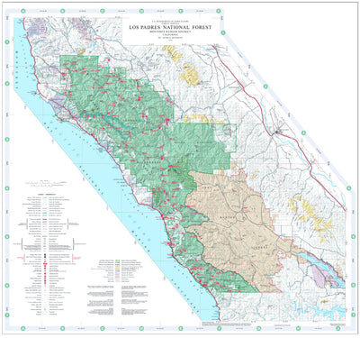
Los Padres National Forest Visitor Map (North)
- Camping
- Hiking
$4.99 USD
National Forest Visitor Maps provide an overview of recreational uses, trails, roads, streams, lakes, landforms, land administration, visitor centers, facilities, campgrounds and picnic areas. The 18 National Forests are mapped at the scale of 1/2 inch per mile (1:126,720). This map is to be use...
Geographic area:
Category:
Parks & Forests
Size:
30.53MB
Publication:
2014
Language:
English
Map bounds
Check nearby maps Customer Reviews
2.5 Based on 2 Reviews
Write a Review Ask a Question - Reviews
- Questions
Filter Reviews:
C
10/22/2021
Customer
Paso Robles, California, United States
very low detail
I have over a dozen maps that I've purchased through Avenza and several that were free. This map of Los Padres National Forest is of the lowest resolution and detail of all my maps.
LH
09/06/2021
lee h.
Castro Valley, California, United States
its ok
This map leaves out a lot of details like roads that are closed by the coastal commision and anti hunting groups. I wasted a lot of time using this map.
What you get with Avenza Maps

Reliable mapping tools
Record GPS tracks, add placemarks, add photos, measure distances, and much more.

Locate yourself with GPS
Avenza Maps offline GPS app on your mobile device can locate you on any map, without WiFi or network connectivity.

The best maps by the best publishers
Download professionally curated digital maps on the Avenza Map Store from the best-renowned publishers.