Enhance your Experience with Angler’s Edge Fishing Maps
Angler’s Edge Mapping is a small business located in Winnipeg, Manitoba, that creates premium hydrographic maps of waterways in Manitoba and Northwest Ontario. They set out to develop high-resolution contour maps that are both high-quality and beautifully designed. They conduct on-the-water hydrographic surveys using high-end sonar/GPS technology to compile and analyze data to reveal structures that could be hiding fish. They mark reefs, points, and flats, as well as functional aspects of habitat.
If you have never used maps to enhance your fishing experience, you may be wondering what all of this means and how it can apply to you. To start, we will explore how to use these maps:
1. Understanding the Scale
The scale will tell you how large the body of water is and the specific areas you will want to fish in. Understanding the scale will help you to plan out your travel times and better prepare for your excursion.

2. Reading the Legend
The legend can tell you a lot about navigating the map and it can also contain symbols representing specific fish species. Understanding the map legend will help you understand the data on the map and find and catch what you are looking for more easily.
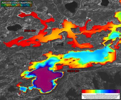
3. Reading Contour Lines
Contour lines shaded in or marked with numbers demonstrate the depth of the water and specific points and reefs. You can also read contour lines to understand how sudden or gradual the water depth change is by looking at how close together or far apart the contour lines are.

4. Finding the Perfect Spot
Use the map to look for fishing hot spots within the body of water, such as creeks or streams that enter a lake. If you know what kind of habitat your fish prefer, you can use the information contained on the map to find things like aquatic vegetation or other fish attractors.

5. Tracking Results
Keep track of which spots were more or less effective for you and mark areas to avoid.

Now that you have a better understanding of how to use maps for fishing, we can dive into what it takes to create these maps. We had the pleasure of speaking with Craig McDougall of Angler’s Edge Mapping all about what it takes to create these maps and how they can help you make the best of your fishing experience.
Avenza: Have you always had a passion for fishing?
Craig: There are pictures of me holding fish when I was 2-3 years old. So yeah, the passion has been there for longer than I can remember.
Avenza: What made you decide to create your own maps?
Craig: I grew up in a town called Pinawa, Manitoba. Pinawa was located in the Canadian Shield, where lakes and rivers are dotted with reefs, points, humps, etc. that can be both hazardous to boaters, but also critically important to fishing success. The maps available for most lakes and rivers I fished were mediocre at best...some were so bad that they were downright dangerous.
I have to thank my late father for being so understanding and nurturing my desire to explore despite the constant damage I did to his boat and motor - I destroyed many props and several lower units while growing up. Once GPS technology became mainstream, I would max out the unit's waypoint capacity (typically 500 or 1000) marking edges of prominent structures to try to get an edge for fishing.
Along a similar timeline, I was learning about cartography and GIS software in school. One day it clicked that the opportunity was there for us to create better maps based on superior survey techniques, and Angler's Edge Mapping was born.
Avenza: What is the most difficult part about conducting on-the-water surveys?
Craig: Surveying certainly is not for everyone. We have very high standards for data collection, and our survey team spends A LOT of time on the water because Canadian Shield lakes are structure-rich. The long days wear on you, both physically and mentally because you really have to stay focused, or you will end up hitting rocks and damaging equipment.
People often say to us "oh it must be nice to be out on the water", and it typically is...for the first couple hours. But as the day drags on and quite often the wind picks up....and you realize you would much rather be fishing than surveying....yeah, you realize that surveying is very much a job.
Avenza: What would you say is the greatest advantage to studying a map before setting out on the water?
Craig: There are a lot of advantages to studying a map before heading out on the water....but I think the greatest would be that an angler can use maps to anticipate where fish are likely going to be at a given time of year, before even setting out on the water.
In spring, it can be as simple as looking for generally shallow areas wherein the water tends to warm up fastest. Then within those areas, look for features such as a main-lake point or a creek-channel to concentrate fish.
Angler’s Edge Mapping offers free overview maps and low resolution maps to greatly improve your experience when working with multiple maps of the same area.
Check out their YouTube channel for tips and tricks on using Angler’s Edge maps within the Avenza Maps app.
Avenza Maps Tips and Tricks
View Angler's Edge Mapping's website, or check out more of their maps in the Avenza Map Store.